Lodging nearby Cosi Casa Hebergement
Mauritius
Lodging nearby Cosi Casa Hebergement
Cosi Casa Hebergement
B13, Grand Baie, MU Mauritius
contacts phone
:
+230 263 8590
Latitude:
-19.9935372
, Longitude:
57.5920728
larger map & directions
read more
nearest Lodging
31 m
Les Appartements Katikïa
Royal Road, Pereybere, Ile Maurice, Pereybere
Lodging
read more
41 m
Luxury Apartment
Coastal Road , Pereybere, Pereybere
Lodging
read more
46 m
Paradizo Residence
Royal Road, Pereybere
Lodging
read more
46 m
Le Beach Club
B13 , Royal Road, Grand Baie
Lodging
read more
74 m
Villa Sabina
Grand Baie
Lodging
read more
76 m
Samvilla
Stephen's shop lane, Pereybere
Lodging
read more
94 m
Pereybere Pearl
B13, Grand Baie
Lodging
read more
119 m
Residence Tamarin a Pereybere
Shella Lane Avenue, Pereybere
Lodging
read more
124 m
Krissy apartments
Bala Lane, Cap Malheureux
Lodging
read more
127 m
Ocean Beauty Boutique Hotel
Pointe d'Azur
Lodging
read more
136 m
6 Teen Studio Pereybere
B13, Grand Baie
Lodging
read more
143 m
Dishay Villa
Beach Lane, Pereybere, Pereybere
Lodging
read more
148 m
Pereybere Beach Apartments
Royal Road Pereybere
Lodging
read more
151 m
Pereybere Hotel
Royal Road, Grand Baie
Lodging
read more
157 m
Flowers of Paradise
Beach Lane, Pereybere
Lodging
read more
171 m
Sanjeev Apartment
Les Flammants street pereybere, Pereybere
Lodging
read more
193 m
Appartement Pereybere
Unnamed Road, Grand Baie
Lodging
read more
211 m
Le Coin d'Azur
Grand Baie
Lodging
read more
269 m
Dodola Lodge
Corner of Jolicoeur and Royal Road, B13, Grande Baie
Lodging
read more
291 m
Résidence Le Beau Manguier
26-27 Mont Oreb Lane, PEREYBERE
Lodging
read more
361 m
Casa Florida Hotel
Grand Baie
Lodging
read more
371 m
Cape Garden Hotel Mauritius Cap Malheureux
Royal Rd Grand Bay Mauritius Pereybere
Lodging
read more
387 m
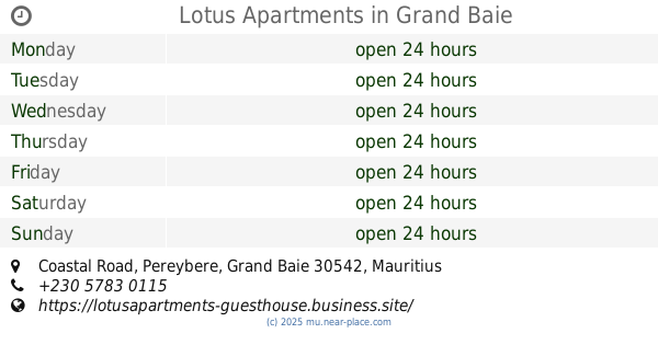
Lotus Apartments
Coastal Road, Pereybere, Grand Baie
Lodging
read more
405 m
Casa Beachtime
B13 Mont Oreb Lane, Pereybere
Lodging
read more
447 m
Lilvilla
No.3, Mont-Oreb Lane, Pereybere
Lodging
read more
📑
all categories
Accounting
Administrative area level 1
Administrative area level 2
Airport
Aquarium
Art gallery
Atm
Bakery
Bank
Bar
Beauty salon
Bicycle store
Book store
Bowling alley
Bus station
Cafe
Campground
Car dealer
Car rental
Car repair
Car wash
Casino
Cemetery
Church
City hall
Clothing store
Convenience store
Country
Courthouse
Dentist
Department store
Doctor
Electrician
Electronics store
Embassy
Finance
Fire station
Florist
Funeral home
Furniture store
Gas station
General contractor
Grocery or supermarket
Gym
Hair care
Hardware store
Health
Hindu Temple
Home goods store
Hospital
Insurance agency
Jewelry store
Laundry
Lawyer
Library
Liquor store
Local government office
Locality
Locksmith
Lodging
Meal delivery
Meal takeaway
Mosque
Movie rental
Movie theater
Moving company
Museum
Natural feature
Neighborhood
Night club
Painter
Park
Parking
Pet store
Pharmacy
Physiotherapist
Place of worship
Plumber
Point of interest
Police
Post office
Premise
Real estate agency
Restaurant
Route
School
Shoe store
Shopping mall
Spa
Stadium
Storage
Store
Supermarket
Taxi stand
Transit station
Travel agency
University
Veterinary care
sublocality level 1
↑