Gas station nearby Engen Filling Station
Mauritius
Gas station nearby Engen Filling Station
Engen Filling Station
Port Louis, Mauritius
contacts phone
:
+230
Latitude:
-20.1559883
, Longitude:
57.5088408
larger map & directions
read more
nearest Gas station
24 m
Engen Plaine Verte
Port Louis
Gas station
read more
72 m
TOTAL Renaissance
Royal Road A1, Port Louis
Gas station
read more
322 m
TOTAL Desforges
Sir Seewoosagur Ramgoolam Street, Port Louis
Gas station
read more
349 m
Shell Filling Station
75 Sir Seewoosagur Ramgoolam Street, Port Louis
Gas station
read more
689 m
Shell Filling Station Latanier
M2, Port Louis
Gas station
read more
1.279 km
Shell Filling Station
Labourdonnais Street, Port Louis
Gas station
read more
1.472 km
Shell Filling Station
Brabant Street, Port Louis
Gas station
read more
1.48 km
TOTAL North Exit
A1, Port Louis
Gas station
read more
1.501 km
Hanibal Taf
AVSCONGRES Ltée, 39 Saint Georges Street, Port Louis
Gas station
read more
1.59 km
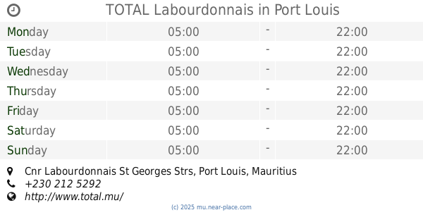
TOTAL Labourdonnais
Cnr Labourdonnais St Georges Strs, Port Louis
Gas station
read more
1.88 km
Shell Petrol Pump Station
A1, Port Louis
Gas station
read more
1.951 km
Engen Petrol Pump Station
A1, Port Louis
Gas station
read more
1.988 km
TOTAL South Exit
Corner A1 Souillac Street, D'Entrecasteaux St, Port Louis
Gas station
read more
2.008 km
TOTAL La Butte
A1, Port Louis
Gas station
read more
2.358 km
Indian Oil Petrol Pump Station
Port Louis
Gas station
read more
2.441 km
Indian Oil Filling Station
A1, Port Louis
Gas station
read more
2.595 km
Shell Filling Station
A1, Port Louis
Gas station
read more
3.238 km
TOTAL Rainbow
Autoroute M1, Bell Village, Port Louis
Gas station
read more
3.806 km
La boutique Plus
Buisson Ardent Terre Rouge
Gas station
read more
4.026 km
TOTAL Terre Rouge
A1 Royal Road, Terre Rouge
Gas station
read more
4.668 km
Indian Oil Filling Station
St. Joseph Road, A4
Gas station
read more
6.896 km
Shell Filling Station
A4, Arsenal
Gas station
read more
12.916 km
Noogaz
Triolet
Gas station
read more
14.455 km
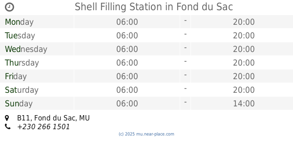
Shell Filling Station
Royal Road, B11, Fond du Sac
Gas station
read more
15.599 km
TOTAL Mont Choisy
B13, Trou-aux-Biches
Gas station
read more
📑
all categories
Accounting
Administrative area level 1
Administrative area level 2
Airport
Aquarium
Art gallery
Atm
Bakery
Bank
Bar
Beauty salon
Bicycle store
Book store
Bowling alley
Bus station
Cafe
Campground
Car dealer
Car rental
Car repair
Car wash
Casino
Cemetery
Church
City hall
Clothing store
Convenience store
Country
Courthouse
Dentist
Department store
Doctor
Electrician
Electronics store
Embassy
Finance
Fire station
Florist
Funeral home
Furniture store
Gas station
General contractor
Grocery or supermarket
Gym
Hair care
Hardware store
Health
Hindu Temple
Home goods store
Hospital
Insurance agency
Jewelry store
Laundry
Lawyer
Library
Liquor store
Local government office
Locality
Locksmith
Lodging
Meal delivery
Meal takeaway
Mosque
Movie rental
Movie theater
Moving company
Museum
Natural feature
Neighborhood
Night club
Painter
Park
Parking
Pet store
Pharmacy
Physiotherapist
Place of worship
Plumber
Point of interest
Police
Post office
Premise
Real estate agency
Restaurant
Route
School
Shoe store
Shopping mall
Spa
Stadium
Storage
Store
Supermarket
Taxi stand
Transit station
Travel agency
University
Veterinary care
sublocality level 1
↑